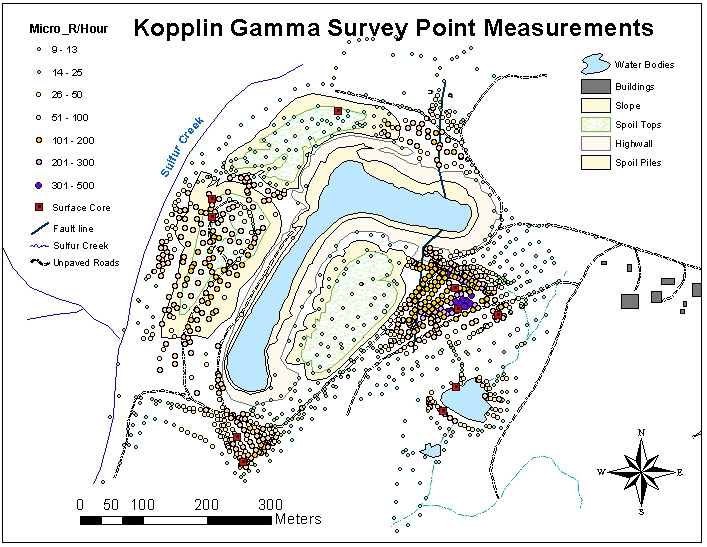
 This image is an Isoline Map of the " Kopplin Uranium Mine" located in the Nueces River watershed in Live Oak County, Texas . An Isoline Map is a map with continous lines joinig points of the same value. This map was created as part of the radiation contamination survey and uses continous lines to outline main geographic features of this map.
Image was taken from: http://http://www.google.com/imgres?imgurl=http://proceedings.esri.com/library/userconf/proc02/pap0167/p01674.jpg&imgrefurl=http://gis.esri.com/library/userconf/proc02/pap0167/p0167.htm&usg=__GuCaL1yUWGZKaNqV78VG5JErJec=&h=547&w=707&sz=143&hl=en&start=0&sig2=GSqSy1B65vUDVxb7uxPsPw&tbnid=XP-SAcKk-6v28M:&tbnh=134&tbnw=173&ei=6VJTTLGmAcOBlAfv-KFu&prev=/images%3Fq%3Disoline%2Bmap%26hl%3Den%26sa%3DG%26biw%3D1276%26bih%3D579%26gbv%3D2%26tbs%3Disch:1&itbs=1&iact=hc&vpx=220&vpy=287&dur=756&hovh=197&hovw=255&tx=181&ty=200&page=1&ndsp=21&ved=1t:429,r:15,s:0
No comments:
Post a Comment